000
WTNT31 KNHC 301453
TCPAT1
BULLETIN
HURRICANE JOAQUIN ADVISORY NUMBER 11
NWS NATIONAL HURRICANE CENTER MIAMI FL AL112015
1100 AM EDT WED SEP 30 2015
…JOAQUIN STRENGTHENS SOME MORE AS IT MOVES SOUTHWESTWARD TOWARD
THE CENTRAL BAHAMAS…
SUMMARY OF 1100 AM EDT…1500 UTC…INFORMATION
———————————————–
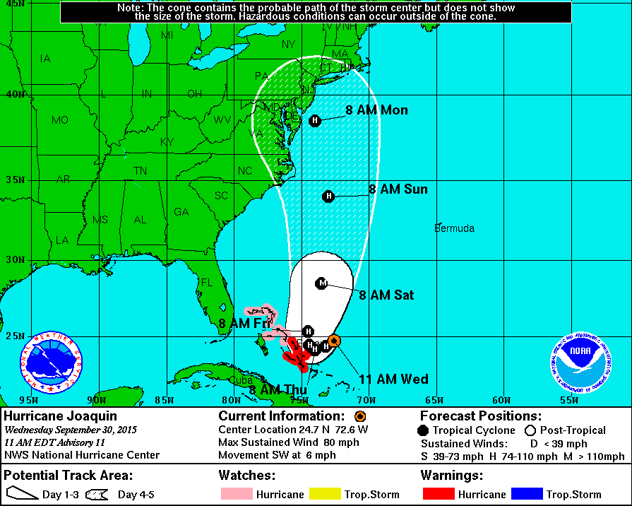
LOCATION…24.7N 72.6W
ABOUT 215 MI…345 KM ENE OF THE CENTRAL BAHAMAS
MAXIMUM SUSTAINED WINDS…80 MPH…130 KM/H
PRESENT MOVEMENT…SW OR 230 DEGREES AT 6 MPH…9 KM/H
MINIMUM CENTRAL PRESSURE…971 MB…28.68 INCHES
WATCHES AND WARNINGS
——————–
CHANGES WITH THIS ADVISORY:
None.
SUMMARY OF WATCHES AND WARNINGS IN EFFECT:
A Hurricane Warning is in effect for…
* Central Bahamas including Cat Island, the Exumas, Long Island,
Rum Cay, and San Salvador.
A Hurricane Watch is in effect for…
* Northwestern Bahamas including the Abacos, Berry Islands, Bimini,
Eleuthera, Grand Bahama Island, and New Providence, but excluding
Andros Island
A Hurricane Warning means that hurricane conditions are expected
somewhere within the warning area. Preparations to protect life and
property should be rushed to completion.
A Hurricane Watch means that hurricane conditions are possible
within the watch area.
For storm information specific to your area, please monitor
products issued by your national meteorological service.
DISCUSSION AND 48-HOUR OUTLOOK
——————————
At 1100 AM EDT (1500 UTC), the center of Hurricane Joaquin was
located near latitude 24.7 North, longitude 72.6 West. Joaquin is
moving toward the southwest near 6 mph (9 km/h). A general motion
toward the west-southwest or southwest is expected to continue
through tonight. A turn toward the northwest and a decrease in
forward speed are forecast Thursday or Thursday night. The center
of Joaquin is expected to move near or over portions of the central
Bahamas tonight and Thursday.
Reports from an Air Force Reserve Hurricane aircraft indicate that
maximum sustained winds have increased to near 80 mph (130 km/h)
with higher gusts. Additional strengthening is expected, and
Joaquin could become a major hurricane during the next couple of
days.
Hurricane force winds extend outward up to 35 miles (55 km) from the
center and tropical storm force winds extend outward up to 125 miles
(205 km).
The minimum central pressure estimated from the Hurricane Hunter
aircraft data is 971 mb (28.67 inches).
HAZARDS AFFECTING LAND
———————-
WIND: Hurricane conditions are expected to reach portions of the
Central Bahamas by Thursday morning. Winds are expected to first
reach tropical storm strength in the warning area tonight, making
outside preparations difficult or dangerous. Preparations to
protect life and property should be rushed to completion. Tropical
storm conditions are possible in the southeastern Bahamas beginning
tonight. Hurricane conditions could reach the northwestern Bahamas
early on Friday.
STORM SURGE: A dangerous storm surge will raise water levels by
as much as 2 to 4 feet above normal tide levels in areas of
onshore flow. Near the coast, the surge will be accompanied by
large and dangerous waves.
RAINFALL: Joaquin is expected to produce 5 to 10 inches of rain
over much of the central Bahamas, with isolated maximum amounts of
20 inches possible over San Salvador and Rum Cay through Friday
night. Rainfall amounts of 3 to 5 inches are possible over the
southeastern Bahamas through Friday night, with 2 to 4 inches
expected over the northwestern Bahamas.
SURF: Swells generated by Joaquin will affect portions of the
Bahamas during the next few days, and will begin to affect portions
of the southeastern coast of the United States by Thursday. These
swells are likely to cause life-threatening surf and rip current
conditions. Please consult products from your local weather office.
NEXT ADVISORY
————-
Next intermediate advisory at 200 PM EDT.
Next complete advisory at 500 PM EDT.
$$
Forecaster Beven
Source: Hurricane JOAQUIN